Infrastructure Development Since 1981
Infrastructure Development Since 1981
We have seen flooding of Indian cities and states during monsoon seasons and the frequency of it is constantly increasing over the last one decade. There has been widely reported loss of lives, properties, live stocks and even wild animals vanishing in flood waters.
Water level monitoring in rivers, lakes and ponds can have a wide variety of benefits including improved visibility on potential flood situations. By utilising water level monitoring systems, it is much easier to rapidly deploy countermeasures in the event that levels become too high or low. Water level sensors serve an important purpose in rivers, warning of floods and unsafe conditions.
One of the challenges for hydrologists and environmental scientists is the need to obtain and sustain in-situ water level measurements for calibrating and improving forecast models, validating satellite and airborne data products, and developing early-warning flood systems. Ground-based measurements are still scarce in many regions. In particular, stream flow monitoring gauges have been declining sharply since the mid-1980s due to high maintenance cost, funding shortages and geopolitical constraints.
There is different use of monitoring system:
While satellite remote sensing techniques have been utilized to monitor oceanic and land surface water with unprecedented global coverage, their measurements are associated with moderate uncertainties and temporal resolution. The NASA's Surface Water Ocean Topography (SWOT) satellite mission will collect high-accuracy measurements of inland surface water elevation (10 cm error for 1 square kilometer areas) at unprecedented scales (10 m to 70 m resolution) using Ka-band interferometric synthetic aperture radar. SWOT will provide global maps of water surface elevation, slope and inundated areas for rivers wider than 100 m. The SWOT interferometric swath will pass over a given location two or three times every 21-day orbital cycle. However, the coarse temporal resolution of satellite altimetry missions such as SWOT and the requirement for monitoring smaller rivers and tributaries underline the significance of in-situ monitoring sites. Measurements of sea surface and river water level using ground-based sensors conventionally rely on contact methods, such as traditional float and stilling well gauges and bubbler pressure gauges or proximal sensing gauges, such as acoustic radar and camera sensors.
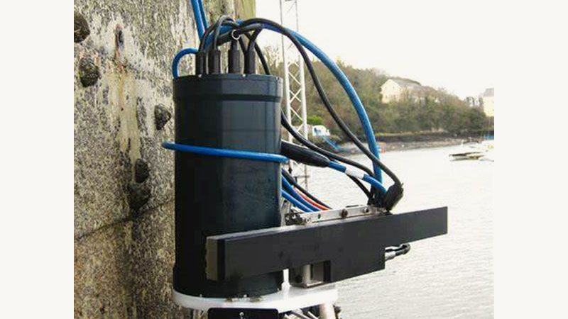
According to scientists at Germany's University of Bonn, conventional water level sensors suffer from one or more limitations – they get damaged in floods, they're difficult to read remotely, they don't measure water levels continuously, or they're too costly. Led by Dr. Makan Karegar, the researchers developed an alternative that doesn't have such problems.
The device takes the form of an antenna that is installed adjacent to a river, out of the water. It continuously receives GPS and GLONASS satellite signals – part of each signal is received directly from the satellite, while the rest is received indirectly, after it's been reflected off the river's surface. The further down the surface is relative to the antenna, the longer the distance the reflected radio waves end up traveling.
IoT-based water level monitoring provides automatic detection of water levels from differently sized water bodies and dams. It is a state-of-the-art system specially designed to inform the users about the real status of the water levels. It is meticulously designed to benefit the monitoring agencies with IoT technology and improve the overall monitoring process.
IoT-based water level monitoring provides real-time autonomous detection of water levels and takes appropriate action based on the levels including overflowing, water depletion, and water usage. Deploying an autonomous system to keep a real-time check upon the water levels provides an effective solution to water-related challenges.
Benefits of Using IoT-Powered Water Level Monitoring
With floods and droughts becoming increasingly frequent as climate change and global warming conditions worsening, there is a compelling need to improve hydrological data collection. Inexpensive open-source hydrological sensors facilitate the cost-effective water monitoring system.