Infrastructure Development Since 1981
Infrastructure Development Since 1981
Although water covers two-thirds of the Earth's surface, however the freshwater constitutes a mere 0.5% of the total volume. Compounding this issue, the demand for water has been steadily rising and is projected to reach a staggering 5890 km3/year by the mid-21st century. Despite the increasing per capita demand, the availability of water has diminished due to various human activities. Currently, over 50% of the global population faces the imminent risk of water stress. The challenge revolves around the insufficient availability of an appropriate quantity of water suitable for use.
The era of climate change necessitates a novel approach to freshwater management, wherein development decisions are no longer made in isolation. Water monitoring is a critical tool to help achieve production and sustainability goals, as well as improve process control. It is important to track the resource contaminants, water quality and storage assets. This approach considers the health and resilience of river basins and wetlands, encompassing the diverse values provided by these dynamic natural systems. Recognizing the critical role of healthy rivers and wetlands in climate mitigation and adaptation, it is imperative to improve the management of these natural infrastructure assets.
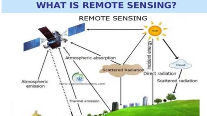
Remote sensing is modern technology that involves the collection of data from a distance, has remarkable applications in various fields. One of its most vital applications is in water resources management. The application of remote sensing in water resources, exploring its significance in monitoring, mapping, and managing water-related issues are important aspect of water monitoring.
The assessment of water availability is significantly facilitated by remote sensing, a key element in sustainable water resource management. Utilizing satellite-based sensors, extensive data on diverse water bodies such as lakes, rivers, and reservoirs is obtained. These sensors gauge parameters like surface area, volume, and water levels, facilitating the monitoring of changes over time. This valuable information contributes to comprehending trends in water availability, pinpointing regions under water stress, and making informed decisions regarding water allocation and distribution.
Preserving the quality of water resources is crucial for both human health and the environment. Remote sensing technologies play a vital role in monitoring water quality by identifying parameters like turbidity, chlorophyll concentration, and temperature. These sensors are adept at detecting pollutants and harmful algal blooms in water bodies, empowering authorities to take prompt actions to safeguard both water quality and public health.
Remote sensing provides an efficient method for detecting sources of water pollution and monitoring their dispersion. Utilizing specialized sensors, it becomes feasible to pinpoint and trace pollutants such as oil spills, chemical discharges, and sediment runoff. This early detection is instrumental in mitigating the environmental impact of pollution, thereby reducing harm to aquatic ecosystems and preserving biodiversity.
Remote sensing techniques facilitate the measurement of surface water flow in rivers and streams. Through the use of radar and optical sensors, scientists can monitor both the flow velocity and volume of water bodies. This data holds significance for activities such as flood forecasting, hydroelectric power generation, and the effective management of water resources, particularly during periods of intense precipitation.
Remote sensing plays a crucial role in monitoring snow cover and glacier parameters in cold regions. Utilizing satellite-based sensors, measurements of snow depth, extent, and melt patterns can be obtained, facilitating the assessment of water availability in regions reliant on snowmelt for their water supply. Furthermore, monitoring glaciers assists in comprehending the effects of climate change on water resources in mountainous areas.
Floods present significant threats to lives, properties, and ecosystems. Remote sensing technology allows for real-time flood monitoring by assessing water levels and inundation extents during rainfall events. This data aids emergency responders and authorities in preparing for floods, evacuating at-risk populations, and implementing flood control measures.
Droughts can have devastating consequences on agriculture, water supply, and the environment. Remote sensing aids in drought assessment by monitoring soil moisture, vegetation health, and water levels in reservoirs. This information assists policymakers in predicting drought events and implementing water conservation strategies to mitigate their impacts.
Groundwater is a crucial source of water supply, especially in arid regions. Remote sensing helps locate potential groundwater reservoirs by mapping subsurface geological structures and identifying areas with high groundwater potential. This valuable information supports sustainable groundwater management and prevents overexploitation of this vital resource.
Efficient irrigation practices are essential for sustainable agriculture and water conservation. Remote sensing provides data on crop health, soil moisture, and evapotranspiration rates, allowing farmers to optimize their irrigation schedules. This technology enhances water use efficiency, minimizes water wastage, and improves crop productivity.
Wetlands are ecologically significant habitats that play a vital role in water filtration and biodiversity conservation. Remote sensing enables accurate mapping and monitoring of wetland areas. By assessing changes in wetland extents and vegetation, scientists can monitor their health and advocate for their preservation and restoration.
The integration of remote sensing in water resources management has brought about a revolutionary shift in how we monitor, map, and address water-related concerns. Whether it's evaluating water availability, monitoring water quality, or detecting pollution sources, remote sensing offers invaluable data that empowers informed decision-making for the pursuit of sustainable water resource management.